
The camp was strategically placed and tasked with several vital projects
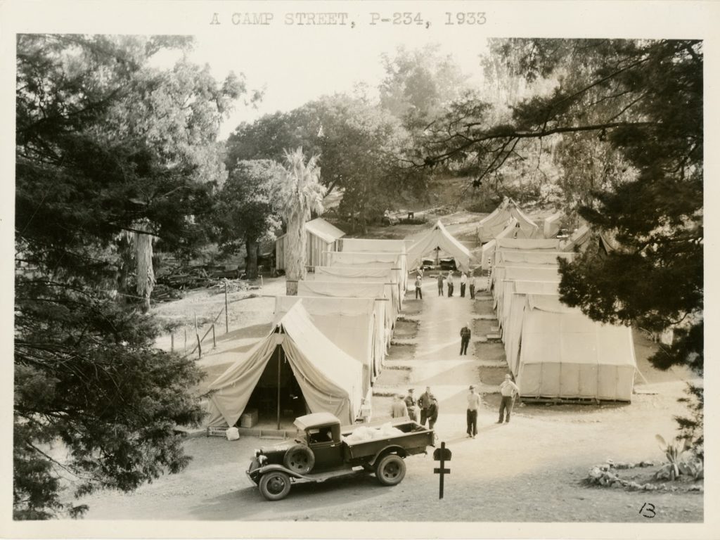
Photo courtesy U.S. Department of Natural Resources Records
California Conservation Corps workers stayed in tents while working on developing Mt. Madonna in 1933. This federal program created jobs for three million men during the Great Depression.
By Mike Monroe
 Upon his inauguration in March of 1933, President Franklin D. Roosevelt rapidly addressed a traumatic national economic crisis — The Great Depression. Within days of taking office, he authorized the charter for the Civilian Conservation Corps with a vision of putting a million men into forestry work. Mt. Madonna was selected to be one of the first CCC camps, perhaps at the request of Santa Clara County government officials, among them supervisor Henry Hecker.
Hecker Pass Highway, or State Route 152, was dedicated in 1928 from the efforts of Santa Cruz and Santa Clara counties. It was within this time-frame the Santa Clara County Board of Supervisors was engaging with the Miller family for the purpose of transforming Mt. Madonna into either a state forest preserve or a county park. Officials had toured the Miller property the year before and were distressed to see the Miller estate had fallen into such disrepair due to neglect and vandalism.
In October 1927 Santa Clara County had proposed the initial purchase of Mt. Madonna property. There was still talk in 1931 of selling the property to the state of California. Perhaps Mt. Madonna could become a state park like Big Basin, but that idea was not realized as finances at all levels of government were constrained.
 Hecker Pass Highway was dedicated in May of 1928 and it was known as the “Yosemite-to-the-Sea” route. Today it is often referred to by its state route number 152. Prior to 1928, the corridor leading from Gilroy toward Mt. Madonna was known as Bodfish Mill Road or the ‘Mill Road.’ After crossing Uvas Creek, the Mill Road formed a ‘T’ at Watsonville Road just as today. Continuing toward Mt. Madonna, the Mill Road passed the turn off for the Whitehurst property and then crossed a cement bridge, following the drainage of Bodfish Creek before terminating at the entryway to Magic Springs about one-third of the way up the shoulder of Mt. Madonna. Henry Miller employed a crew to operate a sawmill at Magic Springs. The circumstances of the construction of the bridge are not known, although cement technology was available and used during Miller’s tenure at Mt. Madonna. The cement bridge traversed the seasonal runoff from Blackhawk Canyon. The bridge and parking zones are today called the Sprig Day Use Area.
Please note that today’s Redwood Retreat Road was designated on the Thompson and West map of 1876 and the 1889 Herrmann Bros. map as the “new” Watsonville Road (designed in 1860). The “old” Watsonville Road was most likely a logging trail, or even an Ohlone trail, that ascended the ridge-line perhaps following, or at least originating at, either of today’s El Matador or Pharmer Roads. Identified on these historic maps, the “old” Watsonville Road snakes up through the chaparral and redwoods to a saddle at the ridge-line and then follows the summit area before dropping into Corralitos. The “new” Watsonville Road was a toll road enterprise when established in 1860 (most likely following another Ohlone trail). It reverted to public ownership in 1874. It had also been referred to as the Gilroy Toll Road or the Pajaro Turnpike. The portion we know as today’s Redwood Retreat Road still connects with Watsonville Road just south of Uvas Creek and the Adams/Chitactac Park.
 This preface is necessary to understand a 1951 hand-drawn map of Mt. Madonna Park that places the CCC camp location at the intersection of today’s Mt. Madonna Road and Pole Line Road. Why was the CCC camp established at this site? The decision to purchase property from the Miller heirs at Mt. Madonna by Santa Clara County did not anticipate the upheaval of the Great Depression, which started in October 1929. Most likely, the future parklands had not yet been developed and an access road from Hecker Pass was still in the planning stages. The CCC camp was strategically placed and tasked with the following projects:
- Improve the artesian well located adjacent to the camp. This well was first developed by the Miller work crews in an area that still remains a “wet meadow.” The improved well was 32 feet deep with a 6-foot by 6-foot cistern and two side tunnels. The well site is still extant.
- Maintain the existing “new” Watsonville Road, and anticipate its renaming to the “Mt. Madonna Road” as well as a name change for the Redwood Retreat Road. This route over the Santa Cruz Mountains was still the primary access means to Mt. Madonna for the CCC crews.
- Complete the grading of a new road and entry point into Mt. Madonna from the Hecker Pass Highway. Originally called the “Main Road,” per the 1951 map, today it is called Pole Line Road because of the power lines overhead. The actual completion of Pole Line Road and the opening of the park is thought to be in 1933 or 1934.
- Construct a deer pen enclosure to secure the white fallow deer that would be an attraction for visitor enjoyment.
- Develop a nearby campground (today’s Tan Oak), in place of the Miller apple orchard, which would be close to the deer pen. An early document noted that initially there were 52 picnic tables and 20 barbecue pits, but that a trail network had not yet been designed. Visitors paid $.25 for picnicking and $.50 for camping. Three rangers and two maintenance men were assigned to the park. At today’s ranger office/visitor center there is a photo of Manuel Arana, one of the first park rangers.
- After a year of work, the CCC camp was reassigned to the New Almaden mining area. The photo we have of the Mt. Madonna CCC camp shows a tent village for CCC boys. After their move to New Almaden in 1934, permanent bunk houses were built by and for the crews. In 1939, the CCC contingent was relocated to the Burchell Road site, again with permanent quarters, which would then be converted into a prisoner-of-war camp for Italian soldiers during World War II.
- With public access in the future and the homesites in poor condition, a salvage agreement with Frank McKinnon was made and completed in 1933. One or two of the bungalows, and some surrounding forest, had been damaged by a fire in 1927 started by transients or bootleggers. All of the splendor of the Henry Miller Estate at Mt. Madonna was just about gone by the time the park officially opened.
A side note: Henry Miller’s first wife, Nancy Sheldon, died during childbirth in 1859. She was 24 years of age. She and her stillborn son were buried in San Francisco’s Lone Mountain Cemetery, and sometime after 1900 they were re-interred at Woodlawn Cemetery in Colma. Several historians have mistakenly suggested that they were buried at Miller’s private family cemetery at the Bloomfield Ranch located off of Castro Valley Road.