The McCutchen family history is murky.
![]()
By Mike Monroe

Mike Monroe
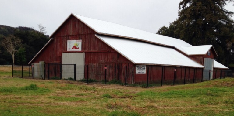
 With the restoration of the Miller Red Barn in Gilroy nearing completion, I decided to dig into the landscape history of the Ranch Side of Christmas Hill Park in anticipation of the public tours of the historic farming structure that will soon become available.
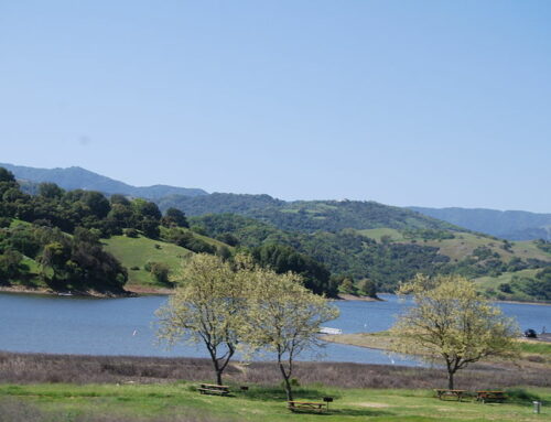
A watershed map, available through the Oakland Museum, identifies McCutchen and Reservoir creeks as seasonal watercourses close to the barn built by the 19th century cattle baron Henry Miller. For those who relish the loads of information maps can provide, it is a really cool document because it plots both the historic channels and the engineered, modern-day creek pathways.
McCutchen Creek forms in one of the many canyons in the southern Santa Cruz Mountains. It’s likely emerging, underground water springs also contribute to this riparian corridor. The map suggests McCutchen Creek was typically impounded by the topography of today’s Eagle Ridge development, forming a pond (or vernal pool) during wet winters. With the construction of Santa Teresa Boulevard and later the Eagle Ridge development, an engineering effort was made to alleviate flooding risks. Engineers modified the creek channel to flow under Santa Teresa Boulevard and drain directly into Uvas Creek near Ascencion Solorsano Middle School.
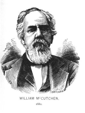
After researching the history of McCutchen Creek, my best hunch is the name of the creek recalls Gilroy’s pioneering McCutchen family. William “Big Bill” McCutchen (1816-1895) was a tall man standing at nearly 6 feet, 6 inches. Born in Tennessee, he relocated to Jackson, Missouri, in 1836 and labored as a farmer. Ten years later, he moved to California. He and his young family joined the ill-fated Donner Party wagon train. McCutchen’s first child, Harriet, died in a makeshift, snowbound cabin near Truckee. The grieving husband and wife first settled in Sonoma. In 1848, they made San Jose their home.
 The McCutchen family history is murky. I found a daughter, Margeline (1847-1903), who was most likely born in Sonoma. Her mother, Amanda McCutchen, died during childbirth at 35 in 1857. Margeline married into the well-known Fine family of Gilroy who owned several hundred acres near Santa Teresa Boulevard and Hecker Pass. She is buried at Gavilan Hills Cemetery.
One McCutchen son, Thomas (1850-1878), was born in San Jose but relocated with his family to Gilroy at an unknown date. In 1870, he left Gilroy. Tragically, while working in Nevada as a stagecoach driver, he was killed in 1878 when Indians attacked his stage.
In 1853 “Big Bill” McCutchen was elected sheriff of Santa Clara County. He died in 1895 after suffering a stroke and now rests in Oak Hill Cemetery in San Jose.
Reservoir Creek is the stream channel that historically flowed along Miller Avenue on its way to Uvas Creek. Oak trees still line the watercourse as it slopes along the roadway. It’s possible a natural basin of water was at one time present on the flat area above Santa Teresa Boulevard. Today, several water storage facilities located near the turnoff for Miller Avenue capture runoff from this watershed. It’s not known if the pioneer rancher Henry Miller developed a vernal pool into an upland reservoir so as to supply a gravity flow source of water for this Glen Ranch where the Red Barn still stands.
 Miller Avenue sweeps across the landscape of southwestern Gilroy in a convoluted fashion. In prehistoric times it served as an Indian trail. After Spanish colonization, it was an alternate horse and wagon road above the Uvas Creek floodplain. The path connected Miller’s Bloomfield Ranch to what was previously the Castro family’s rancho adobe home, and for more than 3,000 years an Indian village known by its Spanish name as “Carnadero” on the west side of Gilroy. Continuing westward on the trail would have led to the passage over the Santa Cruz Mountains that used to be called the “Old Watsonville Road” or the “Pajaro Turnpike.”
Drivers heading north from Bloomfield on today’s Santa Teresa Boulevard find after passing Gavilan College that the roadway reaches a peak point where it splits. One direction veers left following Reservoir Creek on its journey toward the western extent of Gilroy. The creekside route through the Glen was a tree shaded lane. Many of the original American elm plantings remain along today’s Miller Avenue. The trail’s westerly extension would have followed the low foothills toward a crossing place, probably fording Bodfish Creek where the channel was broad, somewhere close to today’s Gilroy Gardens. Henry Miller would have used this upland route to access his properties near Mount Madonna.
The runoff of storm waters following Reservoir Creek now flow through the parking lot of Christmas Hill Park. The water is then pinched into a concrete culvert that dumps directly into Uvas Creek at Silva’s Crossing. My recollection is that Mr. Silva worked for the city of Gilroy and designed the summer or dry season crossing of Uvas Creek. His design employed an array of in-channel water conduits. The roadway surface of Miller Avenue sits atop the conduits which are secured by cables that are sunk into the creek embankments. Engineers always expected heavy storm water flows would over-top Miller Avenue. The alternative would have been the costly design and construction of a lengthy bridge span.
When the Miller Red Barn is ready for the public to visit, I’ll share another column. As Henry David Thoreau would say, “Keep on sauntering.”