
Published in the March 30 – April 12, 2016 issue of Morgan Hill Life
By Mike Monroe
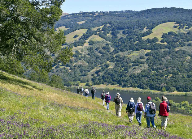
Photo courtesy Ronald Horri
Hikers traverse through the Coyote Ridge Trail with a view of Coyote Lake.
There are many reasons for residents of California to feel proud about our state. We’re grateful, too, for all the wonderful scenic landscapes and coastal views that have been preserved, with our tax dollars and private donations, for all to enjoy in perpetuity. California’s environmental heritage has been the result of the tireless efforts of many individuals and organizations such as John Muir and the Sierra Club, land trusts like the Nature Conservancy, as well as our local cities and counties.
I prefaced this article reflecting upon our preserved open spaces because there is a legacy provided by the University of California at Berkeley that few of us recall. Since 1916, when the National Park Service was established (and now celebrating its 100 year anniversary), there have been four directors who were alumni of Cal.
The first two were Stephen Mather and Horace Albright who were instrumental in conceiving and developing the National Park Service. Newton B. Drury served both during and after World War II and finally, William Penn Mott, Jr served throughout the President Ronald Reagan years when political headwinds were ever present.
It was William Penn Mott, Jr. who first articulated an idea during the 1960s about creating a trail system that would link public lands and greenbelts encompassing the entire Bay Area. Bill Mott was a big thinker, and he had the management and people skills to make things happen. His vision of building nearly 550 miles of multi-use trails traversing ten counties surrounding the San Francisco Bay was more than an overnight dream. It sure has been a process, progressing a mile at a time. But since 1989, when the first segments were dedicated, nearly 400 miles of the project have been designated as part of the Ridge Trail.
Close to our own backyard, the Coyote Ridge Trail runs nearly five miles through the combined Harvey Bear and Mendoza Ranch parklands. Our hike will have two options, both with spectacular views of Coyote Reservoir to the east and the broad expanse of the southern Santa Clara Valley and Santa Cruz Mountains to the west.
The first, and shorter, option is a two-mile round trip walk from the parking area. The turnaround point is where the Mummy Mountain Trail, the Mendoza Trail and the Ridge Trail all intersect. For those who would like to explore another mile further, we will drop down to the Valley Oak Trail to enjoy a magnificent wildflower display – sky lupine, poppies, popcorn flowers and buttercups will be in abundance. The Valley Oak Trail re-connects with the Ridge Trail where we will stop for a break and eye-filling views before returning to the trailhead.
The Mendoza parking lot will be busy that Saturday morning if the weather is fine. The Committee for Green Foothills is also sponsoring a more strenuous hike up the Mummy Mountain Trail beginning at 9 a.m.
Our walk will be much more leisurely with only a few mild elevation changes. Of course, I will be eager to relate history tales and engage in all kinds of conversations just like the grasses bending with the breezes. Wear sturdy shoes, bring water, snacks, binoculars, hat for sun protection and your curious nature. The is no day use fee when parking at Mendoza and there is a porta-potty on site. Visit the Santa Clara County Parks website for a map of Coyote Lake to familiarize yourself with the park and directions to the Mendoza entrance. Please call me if there any questions, especially if there have been heavy rains during the week prior to Saturday April 9.
Keep on sauntering!
Mike Monroe is a business owner and naturalist. He is a docent for Santa Clara County Parks.